Hurricane Debby made landfall near Steinhatchee, Florida around 7 a.m. on Monday morning bringing life-threatening storm surge in portions of the state and the potential for major flooding in the southeast over the next several days.
Data from an Air Force Hurricane Hunter indicated that the maximum sustained winds were estimated at around 80 mph at landfall.
As of 7 a.m. the storm was about 70 miles southeast of Tallahassee and was moving north-northeast at 10 mph.
Some areas of Florida had already received 12 inches of rain, state officials said in an update just before 8 a.m.
"This storm is massive," Florida Division of Emergency Management Executive Director Kevin Guthrie said.
Governor Ron DeSantis Gives Update #3 on Hurricane Debby at State Emergency Operations Center https://t.co/wokUrv8Dbx
— Ron DeSantis (@GovRonDeSantis) August 5, 2024
More than 200,000 customers were without power on Monday morning according to poweroutage.us.
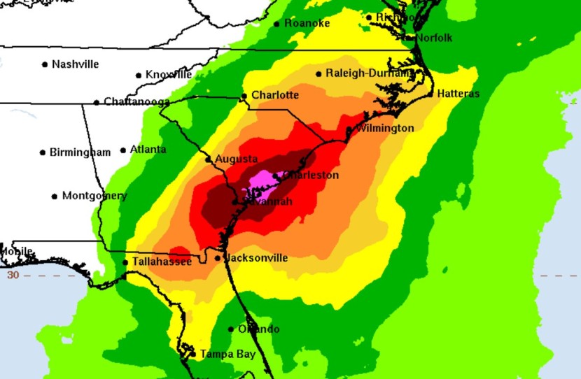
Debby is expected to produce rainfall totals of 6 to 12 inches, with maximum amounts of 18 inches, across portions of central and northern Florida as well as central and northeast North Carolina through Saturday morning.
Across portions of southeast Georgia, the coastal plain of South Carolina, and southeast North Carolina, 10 to 20 inches of rainfall, with local amounts to 30 inches, are expected through Saturday morning. The potentially historic rainfall will likely result in areas of catastrophic flooding.
The National Hurricane Center warned that rainfall will likely result in areas of considerable flash and urban flooding, with significant river flooding expected.


