
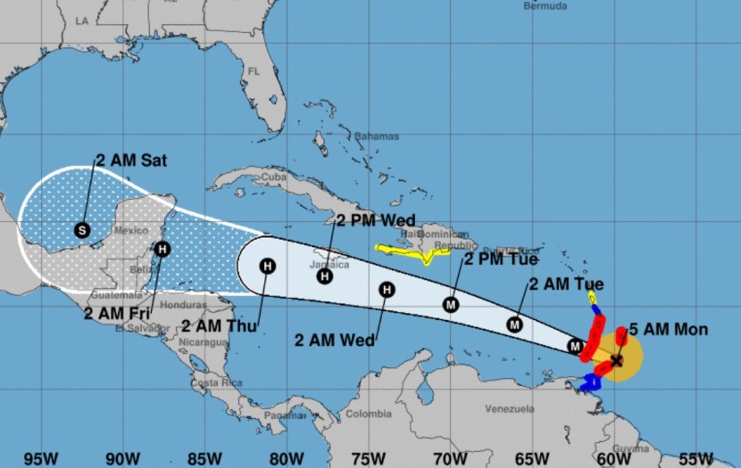
Hurricane Beryl is expected to remain an extremely dangerous major hurricane when it hits the Windward Islands on Monday morning. It was a Category Four storm with maximum sustained winds of 130 mph at 8 a.m. EDT on Monday.
The National Hurricane Center warns that it is a very dangerous situation and residents in those areas should be prepared to evacuate.
Beryl is expected to produce rainfall totals of 3 to 6 inches across Barbados and the Windward Islands through Monday afternoon. Localized maxima of 10 inches are possible, especially in the Grenadines and Grenada. This rainfall may cause flash flooding in vulnerable areas.
The islands could also experience potentially catastrophic winds and a life-threatening storm surge.
The highest risk is expected to be in St. Vincent and the Grenadines.
Hurricane Warnings are in effect for much of the Windward Islands.
Far outer bands of Beryl may produce 1 to 4 inches of rain over portions of southeastern Puerto Rico Monday night into Tuesday.
Beryl is expected to remain a powerful hurricane as it moves across the Caribbean Sea later this week.
A Tropical Storm Watch is in effect for portions of the southern coast of the Dominican Republic and Haiti.
Watches and warnings are expected for other islands as the week goes along.
The first hurricane of the season is the earliest Atlantic Category 4 hurricane on record, although it strength later weakened.


