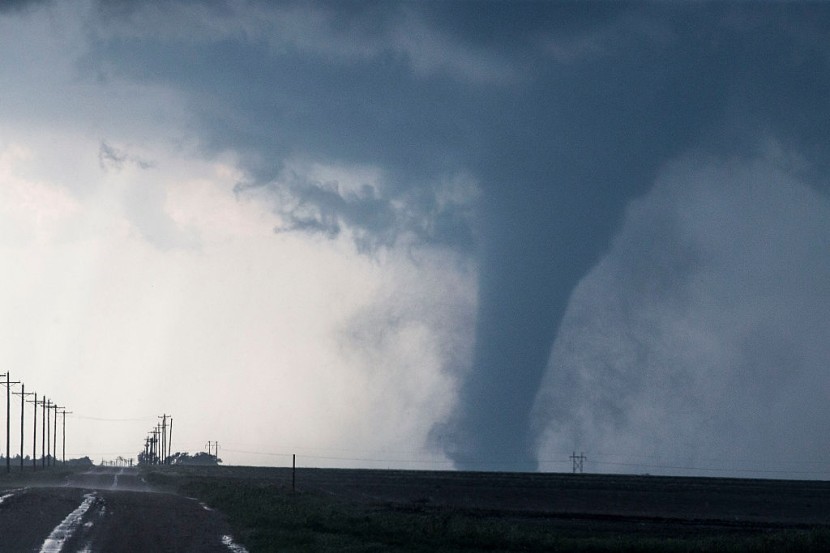
Portions of Texas and Louisiana were devastated by tornadoes and a severe storm system, leaving tens of thousands without electricity.
According to the National Weather Service, tornado warnings for the Dallas-Fort Worth area were lifted by late afternoon, but severe winds and hail lingered.
Intense Storm Sweeps Texas, South
FOX Weather said that more than ten million people in North Texas, southern Oklahoma, and southwestern Arkansas were under a tornado watch on Thursday evening. In San Antonio and Austin, farther south in Texas, hurricane-force wind gusts were observed.
Here is footage of a tornado earlier in Shreveport near Bert Kouns around 5:40 p.m. Storms this evening will continue to be capable of producing short-lived tornadoes . Be prepared to take cover in advance of storms and when Tornado Warnings are issued. Credit: Jamey Bradshaw pic.twitter.com/FdE8IY8em6
— NWS Shreveport (@NWSShreveport) March 3, 2023
The meteorological service reported that a tornado touched down around 100 miles east of Dallas in the small hamlet of Fouke and traveled northeast toward Texarkana at 55 mph. According to poweroutage.us, around 350,000 Texans were without power as of Thursday evening.
Footage of damage from outside of Dallas, TX after a severe #storm hit the area.#Dallas #Texas #Weather #TXwx #Tornado pic.twitter.com/K1Ko3DTCJA
— Chaudhary Parvez (@ChaudharyParvez) March 3, 2023
According to maps provided by Oncor Electricity Distribution Company, 110,000 customers in Dallas County and 42,000 customers in Collin County were without power. More than 4,700 were without power in northwest Louisiana.
Major storm right now in North Texas. 80 mph winds. Tornado sirens going off. I’m hiding in my pantry. 🫣 pic.twitter.com/hOiXE5I0IF
— ❤️🔥 American Heartthrob ❤️🔥 (@sophiesmomrocks) March 3, 2023
Because of the prediction, several school districts, including Dallas and Fort Worth, canceled after-school programs and festivities. Meanwhile, the power disruptions have prompted the cancellation of hundreds of Dallas-bound aircraft.
According to FlightAware.com, Dallas-Fort Worth International Airport and Dallas Love Field Airport have recorded more than 400 total flight cancellations.
A tornado touched down at Louisiana State University in Shreveport, Louisiana, farther east. The National Weather Service released a video of a tornado that occurred near Bert Kouns. Evening storms will continue to be capable of producing brief tornadoes, according to the agency.
Meteorologists report that the storm delivered a "once-in-a-generation" snowfall of up to 7 feet across California and Oregon. Nonetheless, the snowfall is credited with helping decrease and in some cases erase California's drought conditions.
Wind Advisory in Effect in Texas
Almost 8 million people in eastern Texas, northern Louisiana, southern Arkansas, and southeastern Oklahoma are under a Level 4 of 5 moderate risks for severe thunderstorms. These regions consist of Dallas, Fort Worth, and Shreveport, Louisiana.
In Texas, storms coupled with power disruptions. As of 9:15 p.m. CT, more than 320,000 households and businesses in Texas were without power, according to the utility tracking website PowerOutage.us.
Until 10 p.m. CT on Thursday evening, a tornado watch was issued for the Dallas-Fort Worth metropolitan region. A band of severe thunderstorms passing across Texas delivered wind gusts between 60 and 80 mph to the Dallas-Fort Worth metropolitan area, as per CNN.
Several were injured in the Dallas suburb of McKinney when four tractor-trailers overturned on the same stretch of roadway. McKinney police did not indicate the number of injuries. As a result of thunderstorms, airports in Austin and San Antonio implemented a ground stop on Thursday night, requiring flights bound for Dallas to remain at their origin airports, according to the Federal Aviation Administration.
An earlier ground stop for Dallas Fort Worth International Airport existed. Memphis, Tennessee, Little Rock, Arkansas, and Waco, Texas are exposed to a severe storm danger of Level 3 out of 5. Houston, Austin, and Jackson, Mississippi are cities with a danger level of 2 out of 5.
Michael Godfrey, the director of county emergency management in Miller County, Arkansas, said that two persons were unharmed despite being trapped in a house that collapsed during the storms.
Extreme precipitation in the system is also a cause for worry. Extreme storms could produce rainfall rates of up to 2 inches per hour, leading to flash floods. From Oklahoma to Ohio, more than 24 million people are under flood watch. The region is expected to receive up to 5 inches of precipitation, with isolated totals exceeding 8 inches.
This weekend, the same storm system is anticipated to bring severe snow and ice to the Northeast and Great Lakes. This protracted winter storm has already wreaked havoc in the West, and snow is expected to persist into Thursday afternoon in New Mexico.
In lower elevations, up to 5 inches of precipitation is expected, while 8 to 18 inches might fall in higher elevations. Wednesday brought heavy snowfall to the Four Corners region, where Colorado, Utah, Arizona, and New Mexico converge.
Last week's heavy snowfall in Southern California left some stranded and rendered highways inaccessible for days. According to the National Weather Service, more than 100 inches of snow fell in parts of the state.
According to the California Department of Transportation, almost 7 million cubic yards of snow have been cleared thus far, enough to fill 2232 Olympic-sized swimming pools. PowerOutage.us reported that over 52,000 households and businesses across the state were still without power.
Outside of Los Angeles, Mount Baldy has received 106 inches of snow since February 22. This week, more than a fifth of the total snowfall fell in only two days. The Fresno County Office of Emergency Services reported this week that Huntington Lake in the Sierra Mountains received 144 inches of snow during a six-day period.
In addition, the office recorded between 10 and 12 feet of snow at China Peak, resulting in the closure of Highway 16. While California has a small vacation from snowfall for the remainder of the week, another system is anticipated to come into Northern California this weekend.
Related Article : VIDEOS: Severe Storm, Tornadoes Lash US
@YouTube


